SIGN UP FOR MORRIS CREEK HUNTING CLUB! FOR MORE INFORMATION CALL (304) 419-0477
Acid Mine Drainage (AMD)
Morris Creek is two miles long, drains a seven (7) square mile watershed, and empties into the Kanawha River through the City of Montgomery. Aquatic life is impacted by mine drainage, sediment erosion, and other land use practices.
Thanks to dedicated volunteers, generous sponsors, and a nationwide network of mutually beneficial partnerships, Morris Creek is once again a healthy thriving Southern Appalachian ecosystem. We invite you to come celebrate with us, but be ready to get your feet wet. There's still work to do.
Please take time to checkout all other projects and Let us know what interests you the most. We have something for everybody, hope you can join us, and have a pair of waders waiting for you! Explore all MCWA projects using our interactive GIS Data Dashboard.
What is Mine Drainage?
Mine drainage is formed when pyrite (an iron sulfide) is exposed and reacts with air and water to form sulfuric acid and dissolved iron. Some or all of this iron can precipitate to form the red, orange, or yellow sediments in the bottom of streams containing mine drainage. The acid runoff further dissolves heavy metals such as copper, lead, and mercury into groundwater or surface water. The rate and degree by which acid-mine drainage proceeds can be increased by the action of certain bacteria.
Problems associated with mine drainage include contaminated drinking water, disrupted growth and reproduction of aquatic plants and animals, and the corroding effects of the acid on parts of infrastructures such as bridges. (Source: USGS)
Acid Mine Drainage Remediation
Featured AMD Projects

- Possume Hollow
- Blacksnake Hollow
- Lower Mainstem
- Upper Mainstem
Total: $1.6 Million
Possum Hollow Project

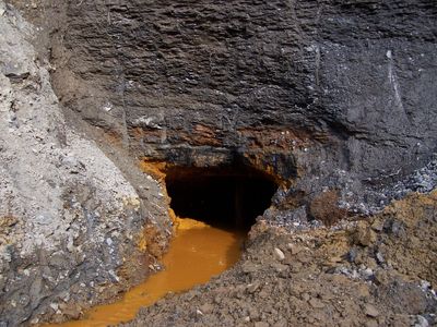
This is a before photo showing the bricked up entrance to an old coal mine. Acidic mine drainage was seeping out and entering Mill Creek, which is a major tributary of Morris Creek.
Thanks to the Watershed Cooperative Agreement Program with WVDEP and OSMRE, the entrance was properly sealed and drainage controlled. A portion of the original structure used to seal the mine was preserved as a historical and culture landmark.
The acidic drainage is routed through an engineered limestone pond, while the alkaline limestone works as a buffer to raise and balance the water's pH.

Aerial Imagery of Possume Hollow project site.
Blacksnake Hollow Project
Acidic drainage seeping through cracks and crevasses in the mountain and popping out near an active natural gas well.
Watershed volunteers joined state and federal agency staff on site tours and project planning discussions.
This photo shows the project a few months after completion. Unfortunately, this site is currently being heavily impacted by sediment erosion problems.

Aerial Imagery of project site. Look close and you will see that a large landslide has greatly compromised the site.
Lower Mainstem Project
In the early days, we referred to the Lower Mainstem site as, "The Creek Killer".
Acidic discharge emanating from the old mine is routed through a passive limestone pond system. The limestone raises the pH of the mine water, which in turn, causes metals that were once diluted in the acidic water to resuspend and fall out into the pond instead of the stream.
Outlet from Lower Mainstem project and stream monitoring sampling location.

Aerial Imagery of Lower Mainstem project site.
Upper Mainstem Project
Problems at the Upper Mainstem site were caused by mine water seeping out of the hillside. Over time, it created an acidic iron shelf, which slowly encroached upon the stream and suffocated aquatic life.
Work space around the site was extremely limited. The only solution was to move the stream.
This photo was taken shortly after construction was completed. Today the site is grown over and looks much more natural. Come see for yourself!

Aerial Imagery of Upper Mainstem project site.
"Building a better tomorrow today one drop at a time"